HOW TO BUY LAND IN ANTIGUA GUATEMALA - AVOIDING NATURAL DISASTERS
A QUICK GUIDE TO SAFEGUARD YOUR INVESTMENT AND PROPERTY

For the past five years, ever since the COVID pandemic began, our beautiful town of Antigua Guatemala has grown like never before. This new interest in our valley of Panchoy has brought newcomers looking for land, homes to rent, and a new life in the perfect weather of this historic city.
There has been an explosion of construction to the south in the towns of San Pedro Las Huertas, San Miguel Escobar, Santa Catarina Bobadilla, and even San Juan El Obispo.
To the west, in Santa Ana and San Cristóbal el Bajo.
Further west, numerous and vast developments have sprawled in Ciudad Vieja, San Lorenzo El Cubo, and Alotenango.
Unfortunately, some or most of these new developments stand in the way of nature — built with shoddy or subpar materials, poor environmental design, and licenses that should never have been approved by the municipalities, given our recent history of natural disasters that have struck those localities.
Antigua Guatemala has a long and proud history of natural disasters. We are a town moved to its core by time and chaos, yet rebuilt — always — by those who believe it’s the most magical small city in the world. But we forget. As a species, we have short memories. We overlook the scars on the earth around us. The famous colonial ruins? They’re just the surface wounds. The valley hides deeper ones.
This is a guide for both locals and foreigners alike to be better informed of the potential risks that lie latent in our city of Antigua Guatemala. These are the natural disasters that have left a mark on this town before — and might again, someday. So if you’re looking to buy land, rent a home, or settle here for good, it’s essential to understand where — and what — you're building on. There's no guarantee you'll live through the next earthquake, flood, or fire. But whether it hits in 5, 10, or 100 years, your preparation — or your ignorance — will shape the outcome.
1. DRY SEASON – FOREST FIRES
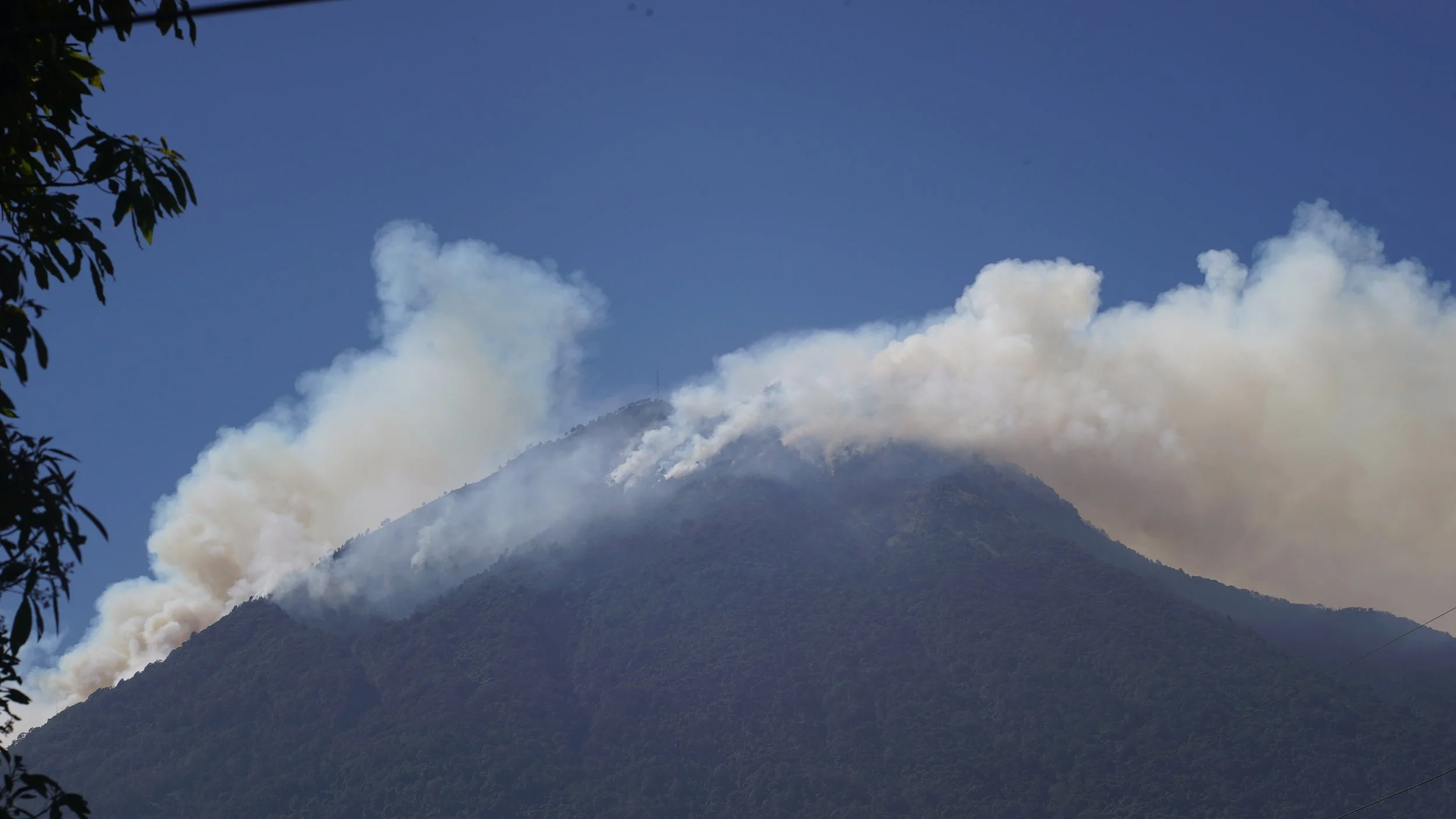
In early 2024, Volcán de Agua burned. The fire mostly scorched the southern face near Palín, Escuintla, but the risk is constant. Agua’s shape and wind patterns — northern and western winds — usually push fire up, not down.
From November to June, the dry season paints the mountains in shifting colors. South-facing slopes stay green. Elsewhere, the earth dries to dust.
Cerro de la Cruz, to the north, was replanted with eucalyptus in the 1970s — beautiful, yes, but dangerously flammable. It’s a matchstick forest above town.
Things to look out for:
Check the vegetation around you. If it's evergreen even during peak dry season, the risk is most likely low.
Be wary of the traditional rosa (farmers burning the soil at the end of each harvest), as it sometimes becomes an uncontrolled fire.
Check wind patterns and directions.
Take precautionary measures in your landscaping and home maintenance to minimize the risk of fires on your property.
Remember the rule of 30/30/30 — most fires start during those conditions: over 30°C in temperature, over 30 km/h winds, and humidity below 30%.
Install metal or fire-resistant roofing and avoid wood shingles, especially in exposed hillside areas.
Create a defensible space around the home by clearing flammable vegetation within at least 10 meters.
Store water on-site (e.g. cisterns or tanks) with hoses for emergency use during fire season.
Stay informed via INSIVUMEH or CONRED bulletins during red flag warning days.
2. EARTHQUAKES – ANTIGUA’S OLDEST ENEMY
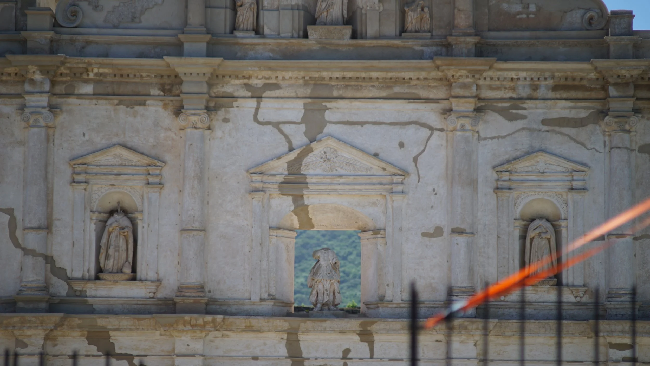
Antigua has been leveled by earthquakes seven times in 500 years. The quake of 1773 was so destructive that the capital was moved to what is now Guatemala City.
Other destructive events followed — and the July 2025 earthquake swarm reminded us that the earth hasn’t stopped shifting. Adobe homes, old colonial structures, and poorly built homes in Santa María de Jesús bore the brunt.
What to do:
Build on rock, not sand.
Avoid old walls and karstic limestone cliffs.
Always demand from builders: strong foundations, sound structural analysis, thick columns, and premium-quality modern materials.
Be wary of new developments — many are built fast and cheap.
Install seismic shut-off valves for gas lines to reduce fire risk after a quake.
Secure heavy furniture and appliances (like bookshelves and water tanks) to walls.
Keep an earthquake go-bag (first aid kit, flashlight, water, documents) in an accessible spot.
Hire a local structural engineer to review building integrity before buying older homes — especially adobe.
Check your property insurance — most Guatemalan home insurance policies don’t cover earthquakes unless added explicitly.
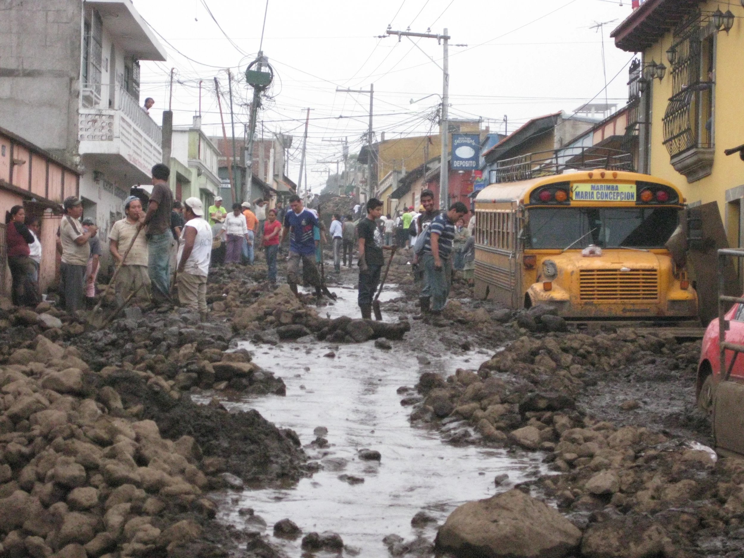
3. RAINY SEASON – FLOODS & MUDSLIDES

Old farmers say: the first two weeks of September are the most dangerous. When the rains arrive, they turn their eyes to the slopes of Volcán de Agua and pray.
Calle del Agua in Santa Ana becomes a river every year. That name isn't poetic — it’s historic. The river flows down into Alameda del Calvario.
Panorama used to be a low-lying marsh adjacent to the Guacalate River and, to this day, is prone to flooding every rainy season.
During hurricanes like Mitch, Stan, and Agatha, we’ve seen lahares — volcanic mudflows — surge down Agua’s ravines. These flows are powerful, fast, and deadly. And yes, “water has memory.” These are high-risk areas. The lower you are, the more the dispersal pattern fans out into a delta.
Many new housing projects on the outskirts of town — especially to the south and east — are built directly in flood zones. These should never have been approved. But here we are.
Things to look out for:
Ask local neighbors if they recall flooding in the area over the past 50 years. You’d be surprised by the stories families with generations here can tell.
Never build or buy in a lahar — or in the path of one.
Be wary of what is being built uphill from the nearest lahar near you.
During peak rainy season, be ready to evacuate if need be. Flash floods can happen in minutes.
Even if flooding isn’t an issue, humidity can greatly affect your property and quality of life.
Raised homes with good humidity isolation are always preferred.
Notice the downhill flow of rainwater near you and monitor soil saturation — it’s a tipping point in terms of safety.
Look out for large boulders and uprooted trees; these may be remnants of past flooding events on your property.
Install French drains or permeable landscaping to reduce runoff pressure near your property.
Avoid homes with below-ground living spaces or those at the base of steep slopes.
Get a soil study before building — unstable soils (especially clay-rich or volcanic ash) absorb water poorly.
Check if local drainage infrastructure exists — some new developments simply redirect water onto neighbors.
Use lime-based plasters or anti-humidity paints indoors to mitigate mold from excessive ambient moisture.
4. VOLCANIC ACTIVITY – LOW, BUT NOT ZERO
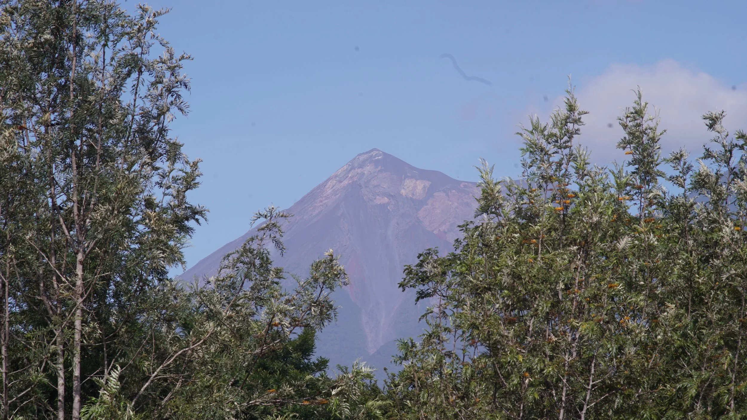
Antigua as a town is not prone to volcanic risk, mainly due to wind patterns and its distance from nearby active volcanoes: Fuego to the west and Pacaya to the south (behind Volcán de Agua, which has been dormant for at least 8,000 years).
During its largest recent eruption in 2010, Pacaya dropped significant ash into our valley. But it was Hurricane Agatha, which struck simultaneously, that caused the most damage. Ash during dry spells can usually be swept away without much hassle.
Fuego’s activity can be seen clearly from most vantage points in the valley. And in our 500-year history, Antigua has never been affected by it beyond ashfall. Eruption and wind patterns affect the southwestern side of the colossus. During the deadly 2018 eruption that swept away entire villages and golf courses, the damage was limited to those flanks — dangerously close, but not ours.
Things to look out for:
Ask yourself: how close am I to known volcanic lahar or pyroclastic flow routes?
Use Google Earth to check your proximity to lahar zones with no vegetation — a bellwether sign that eruptions have burned the land recently.
Check with CONRED (Guatemala’s disaster prevention agency) to see which areas are usually evacuated or put under alert during eruptions.
Own N95 or P100 masks to protect from inhaling ash particles during eruptions.
Install gutter guards or filters to prevent volcanic ash from clogging rainwater collection systems.
Avoid using ashfall water for consumption or irrigation until filtered — ash contains toxic minerals.
Keep vehicles under cover or use car covers during ashfall to prevent long-term paint damage and engine issues.
Stay connected to alert systems like CONRED’s WhatsApp groups or local municipal radios for evacuation guidance.
Antigua is a marvel. Its richness isn’t limited to history, food, religious tradition, and natural beauty. But it’s also full of quiet risks, written into the land itself.
And if you still fall in love with this town — as so many do — then at least do so with your eyes wide open.